-
-
-
-
-
-
-
-
-
-
-
-
-
Sutton Salt Lake Wetland Management Area
-
-
-
-
-
-
-
-
-
-
-
-
-
-
-
-
-
-
Sutton Salt Lake Wetland Management Area
Description:
Salt Lake (2 ha, near Sutton) is a shallow saline lake on the southern edge of the Strath Taieri Plain. Swampy margins with succulent herb, rush and sedge vegetation. Part of Sutton Salt Lake Scenic Reserve (142 ha) which embraces other tarns, seepages, grassland and shrubland communities. 1
Type/Class:
Marsh 2
Size:
131.2 ha.
Altitude:
220-260 m above sea level.
Approximate location:
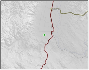
2.2 km West of the intersection of Kidds Road and Sutton-Clarks Junction Road, Middlemarch.
NZTM (centre point): E1372800 N4949100
Regional Plan: Water for Otago.
Schedule 9 Regionally Significant Wetland, no.142, Map F55
Territorial Authority:
Dunedin City Council.

Recorded Values:
Value |
Description |
|
|---|---|---|
A1 |
|
|
A5 |
|
|
A2-A4, A6-A9 |
No relevant information is currently held by the ORC. |
Other Information:
•Part of the area includes a QEII conservation covenant. “14”
•Listed as an Area of Significant Conservation Value in the Dunedin City District Plan. Described as a succulent herb swamp, rush and sedge swamp of regional/local significance. “28”
•Soil classified as Saline Immature Semiarid Soil. “8”
•Presence of native halophyte coastal goosefoot (Chenopodium glaucum). “8”
•Invertebrate species recorded at the site include Arctesthes catapyrrha, Eudonia sabulosella, Eudonia leptalea, Eurythecta zelaea, Lycaena boldenarum, Orocrambus corruptus and Phylacodes cauta. “8”
•The Department of Conservation considers the Sutton Salt Lake Wetland Management Area to be a moderately important site for biological conservation. On a scale from 1 (highest value) to 11 (lowest value) the site was given a rank of 6, on the basis of its geographical extent, relative representativeness (the extent to which the site represents the assumed 1840 condition), diversity and rarity of biota and soils. “8”
•There are five main vegetation zones that have been described at the lake:
1.A narrow fringe of salt tolerant vegetation at the lakes margin, consisting of three sub component zones, with Lilaeopsis sp. occupying the lower most zones, Selliera sp. above the Lilaeopsis, and a zone of pure salt grass (Puccinellia fasciculata), with salt grass (Puccinellia stricta).
2.An algal zone submerged in winter or when lake is full.
3.Rough pasture with exotic grasses, hard tussock (Festuca novae-zelandiae) and a few shrubs.
4.Communities on rock outcrops.
5.Shallow boggy depressions near the lake. These are dominated by club rush (Eleocharis acuta), jointed rush (Juncus articulatus) and common rush (Juncus effuses). Amongst these plants are Remuremu (Selliera radicans), common water milfoil (Myriophyllum propinquum), Pratia perpusilla and water purslane (Lythrum portula). In wettest areas, floating sweet grass dominates, with red pondweed/mānihi (Potamogeton cheesemanii) and red water fern/kārearea (Azolla filiculoides). Ranunculus glabrifolius dominates between boggy depressions along with exotic grasses and clovers. Carex dipsacea, Glen Murray tussock (Carex flagellifera) and oval sedge (Carex ovalis) grow at the edges of boggy patches.
•Waterfowl present on the lake include White-faced Heron (Ardea novaehollandiae novaehollandiae), Black Swan (Cygnus atratus), Paradise Shelduck (Tadorna variegata), Mallard (Anas platyrhynchos), New Zealand Shoveller/Kuruwhengi (Anas rhynchotis variegata), South Island Pied Oystercatcher/Torea (Haematopus ostralegus finschi) and Southern Black-backed Gull (Larus dominicanus). “14”
•Aquatic fauna includes Brachionus plicatilis (very abundant), Microcyclops (Metacyclops) monacanthus (scarce), Diacypris spp. (abundant) and Ephydrella spp. (scarce), including an endemic species of Ephydrella novaezealandiae. “14”
•Threats include trampling and grazing by cattle, and burning of plant communities adjacent to the lake. Possible threats include over sowing and top dressing. Construction of maimai also poses a problem. “14”
•There is the potential threat of deliberate or incidental fertiliser application. “8”

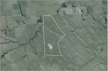
Aerial view of Sutton Salt Lake Wetland Management Area (March 2006)

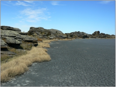
Sutton Salt Lake (January 2010) “51”

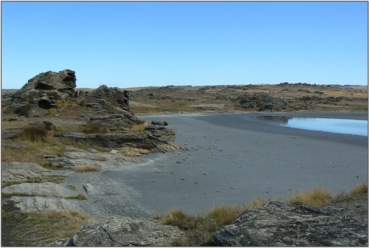
Sutton Salt Lake (January 2010) “51”
References
1 Otago Regional Council (2004) Regional Plan: Water for Otago. Published by the Otago Regional Council, Dunedin.
2. Ausseil, A.G., Newsome, P., Johnson, P, (2008) Wetland Mapping in the Otago Region. Landcare Research Contract Report prepared for the Otago Regional Council.
8. Allen, R.B. and McIntosh, P.D. (1997) Guidelines for conservation of salt pans in Central Otago, Science for Conservation: 49. Published by the Department of Conservation, Wellington.
14. Cromarty, P. and Scott, D.A. (eds.) (1995) A Directory of Wetlands in New Zealand. Published by the Department of Conservation, Wellington.
28. Dunedin City Council (1999) Dunedin City District Plan. Published by the Dunedin City Council, Dunedin.
51. Otago Regional Council - Photo Archive.
