-
-
-
-
-
-
-
-
-
-
Hungerford Point Saltmarsh
-
-
-
-
-
-
-
-
-
-
-
-
-
-
-
-
-
-
-
-
-
Hungerford Point Saltmarsh
Description:
Saltmarsh with high botanical value and adjacent coastal forest located near the mouth of the Catlins Lake. 90
Type/Class:
Saltmarsh.
Size:
7.1 ha.
Altitude:
0 - 20 m above sea level.
Approximate location:
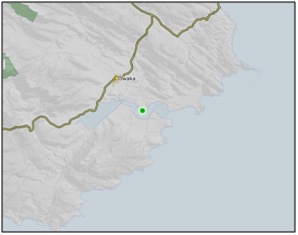
2 km South of the intersection of Pounawea Road and Duttons Road, Pounawea.
NZTM (centre point): E1345750 N4847540.
Regional Plan:
Schedule 9 Regionally Significant Wetland, no.63, Map F32.
Territorial Authority:
Clutha District Council.


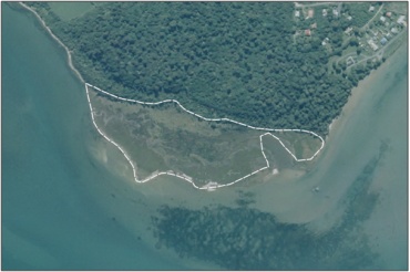
Aerial View of Hungerford Point Saltmarsh (March 2006)
Recorded Values:
Value |
Description |
|---|---|
A3 |
High diversity of wetland habitat types. The saltmarsh is part of a vegetation sequence which grades from marsh through intermediary shrubs and finally into mature podocarp forest. 71 |
A5 |
Scarce in Otago in terms of its ecological or physical character. Less than 15% of marshes remain in Otago. 2 The opportunity to observe saltmarsh and adjacent coastal forest is now very limited as examples of this kind of vegetation sequence have become extremely rare. 71 |
A1, A2, A4, A6 - A9 |
No relevant information is currently held by the ORC. |
Other Information:
- Saltmarsh community with glasswort (Sarcocornia quinqueflora) being the dominant species. Taller plants can be found at the upper edge of the marsh such as rushes and shore ribbonwood. 71
- The high parts of the marsh are composed of a hard, peaty upper layer in contrast to the sandy base of the lower marsh. 71
- Recovering podocarp forest with few white pine/kahikatea (Dacrycarpus dacrydioides), totara-black pine/mataī (Prumnopitys taxifolia), and red pine/rimu (Dacrydium cupressinum) that survived the logging remaining as mature trees. These can be easily distinguished from new growth by their broad trunks and towering height. 71
- The main canopy of the forest is now composed almost entirely of kamahi, with rata-kāmahi (Weinmannia racemosa) increasing to the west and south west of reserve. Lower down in the layers is a diverse understorey of fuchsia, wineberry, mahoe, coprosma, red matipo and tree ferns. Crown fern, other ferns and some herb species provide a dense ground cover. 71
- Between the marsh and forest is a stand of manuka, flax and tall rushes. 71
- Bird species present on the saltmarsh all year round include White-faced Heron (Ardea novaehollandiae novaehollandiae), Oystercatchers (Haematopodidae) and other waders. Migratory Godwits (kuaka) feed in flocks on the mudflats in summer, while Royal Spoonbills (Platalea regia) also make occasional visits. 71
- Hungerford Point Saltmarsh is adjacent to the coastal marine area, which is covered by the Regional Plan: Coast for Otago.
References:
2 Ausseil, A.G., Newsome, P., Johnson, P. (2008) Wetland Mapping in the Otago Region. Landcare Research Contract Report prepared for the Otago Regional Council.
71 Department of Conservation. Super Sites for Conservation Education – Catlins. Published by the Department of Conservation, Wellington. Report prepared for the Otago regional Council, Dunedin.
90 Department of Conservation (2010) Comments on the Consultative Draft Proposed Plan Change 2 (Regionally Significant Wetlands) to the Regional Plan: Water for Otago. Department of Conservation - Otago Conservancy, Dunedin.
