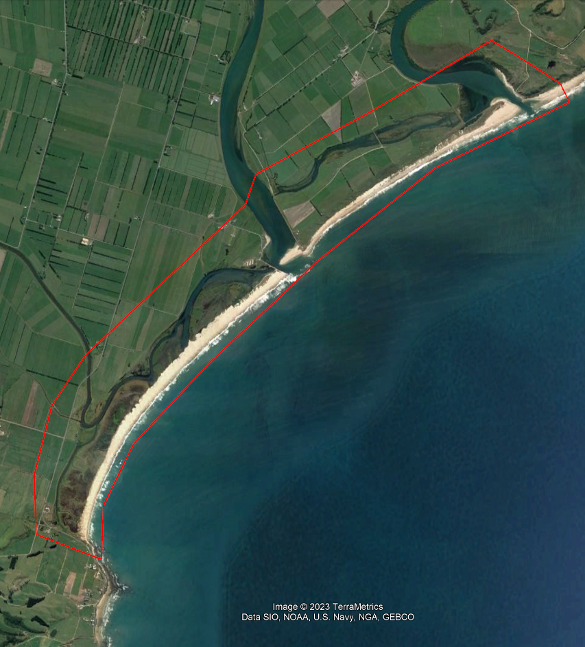
While there is no immediate danger to the public, recent storm and erosion damage around the Koau mouth of the Clutha Mata-Au River prompted ORC to commission Landpro to send up a plane today to capture ground level LiDAR data and high-resolution aerial imagery of the coastline.
The plane began its fly-over survey about noon today; coinciding with low tide.
ORC’s Manager Natural Hazards Dr Jean-Luc Payan says data from the LiDAR flyovers will help ORC assess how the changes observed may modify or exacerbate the potential natural hazards in the area, such as flooding hazards.
“They will map the recent changes of ground levels and shoreline position in the coastal part of the Clutha delta, at both mouths of the Clutha Mata-Au. The high-resolution topography will allow comparison of shoreline changes with previous datasets,” he says.


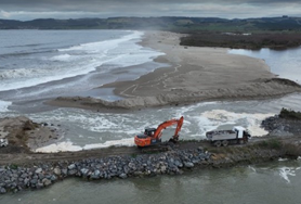
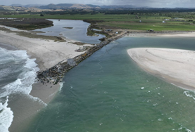
Left, Puerua Outfall July 2023, and right, February 2023. Photos ORC
“There’s been rapid erosion alongside the ORC rock wall training line structure at the Clutha River’s Koau mouth, including damage to several of the outfall culverts which drain the Puerua River to the Clutha,” Dr Payan says.
ORC’s Manager Engineering, Michelle Mifflin, says the area is regularly monitored and on 1 July the large swells prompted a heightened monitoring and a response plan was initiated.
That was focussed on stabilising the river mouth training line which includes the Puerua outfall culverts, to maintain effective drainage to the Lower Clutha Drainage scheme, she says.
The response plan included reusing rock which was in situ plus additional armour rock sourced from local quarries and suppliers. The work may continue on into next week and is not expected to disrupt other ORC work programmes in the area, Ms Mifflin says.
The river mouth rockwall training structures are designed to limit off-setting of the mouths and to confine the outlet flows for efficient discharges to the ocean in all river flow and sea conditions.
Since last weekend there have been rising swells from the South, associated with a low in the Tasman Sea, with the wave action and a storm surge combining with high river flows and high tides, causing the damage.
The weather outlook only has expectations of minor rainfall, of less than 10mm daily, for the Puerua catchment on 13 and 16 July.
Local shoreline retreat, or coastal erosion
ORC’s Natural Hazards Analyst, Tim van Woerden, says that in general, there has been ongoing shoreline retreat, or coastal erosion, along the Clutha delta and Molyneux Bay coastline for a long period, and it’s recognised as a highly dynamic environment.”
He notes during the week there has been rapid erosion alongside the ORC rockwall training structure at the Clutha River’s Koau mouth, including damage to several outfall culverts which drain the Puerua River to the Clutha Mata-Au River.
There has also been erosion of sections of the natural dune system, including at the Koau mouth area.
Mr van Woerden says the Puerua River has naturally formed a new outlet directly to the coast, and while the lower section of the Puerua River may have remained at relatively higher levels, it is now slowly receding as the river flows reduce.
Because the river was relatively high for a time, the ORC drainage scheme may have a reduced capacity for drainage from the Paretai area; with gravity drainage likely impacted, but the nearby pump station is still operating.
The future assessments will consider a full range of factors influencing the future natural hazard risks, such as shoreline retreat, sea level and groundwater rise, and climate change effects on precipitation and river flows, Mr van Woerden says.
There have been regular inspections of ORC infrastructure in the area and drone surveys have also been used, he says.
Background to ORC work programme in the area
Dr Payan says there are several potential natural hazards which may impact in the lower Clutha Delta area, such as river flooding, coastal erosion or storm surge flooding.
ORC has completed assessments for these – summarised in the 2016 report Natural Hazards on the Clutha Delta, Otago and in the 2021 report Molyneux Bay and Clutha Delta Morphology Investigation
ORC manages the Lower Clutha Flood Protection and Drainage Scheme on the Clutha Delta, providing protection to an area of 9300 hectares. The scheme includes 110 kilometres of floodbanks, 153 km of drains and 5 pump stations.
“ORC has already identified in its infrastructure strategy that natural hazards and climate change are two significant issues that will affect the performance of the Lower Clutha Flood Protection and Drainage Scheme in future,” Ms Mifflin says.
Within the vicinity of the coastal area, this scheme includes floodbanks, river mouth training structures, and drainage outfalls.
The river mouth training structures are designed to limit off-setting of the mouths and to confine the outlet flows for the efficient discharge to the ocean in all river flow In addition to the maintenance of its infrastructure, ORC is currently developing a long-term strategic and adaptive approach to respond these complex natural hazards at the mouths of the Clutha River.
This work includes monitoring programmes, such as groundwater and coastal erosion, natural hazards investigations and adaptation pathways development.
More background, committee paper from Dec 2021 and accompanying Media Release.

The route this afternoon of the LandPro plane undertaking LiDAR
