-
-
-
-
-
-
-
-
-
-
-
-
-
-
-
Resilience and climate
Community Outcome: Otago builds resilience in a way that contributes to community and environmental wellbeing through planned and well-managed responses to shocks and stresses, including natural hazards.
Relevance
Understanding how natural hazards may affect people is important because knowledge directly influences decisions about where to live and work, as well as how people plan for safety, preparedness, and recovery.
Being ready for natural hazards in Otago helps keep people safe, protects homes and livelihoods, and strengthens the region’s ability to recover when emergencies occur.
Current situation
Summary
Awareness of natural hazard risks is increasing, and more people are taking steps to prepare. However, further progress is needed to support truly resilient communities.
Supporting information
Between 68% and 93% of respondents to the EMO Community Resilience Survey indicated that they were aware of natural hazards that may impact them in 2025. This represents an improvement from 2024.
Participants generally show a good understanding of natural hazards and know where to find information. However, there are concerns about access to information during power or internet outages. Views on climate change-related impacts vary widely, ranging from acknowledgement to outright denial.
Visits to the Emergency Management Otago website were:
- 27,816 visits from 1 July 2023 to 30 June 2024
- 33,188 visits from 1 July 2024 to 30 June 2025
Visits to the ORC Natural Hazards Database Portal were:
- 20,500 visits since the new portal launched at the start of the current financial year
The ORC Natural Hazards Team received and responded to:
- 94 natural hazards-related enquiries from 1 July 2023 to 30 June 2024
- 143 natural hazards-related enquiries from 1 July 2024 to 30 June 2025
- 103 natural hazards-related enquiries from 1 July 2025 to 31 December 2025 (projected total of 206 enquiries by year end)
Note: While website visits and enquiries suggest increased access to information, they do not provide a direct measure of awareness, as people may also be obtaining information from other sources.
In terms of readiness, the EMO Community Resilience Survey shows mixed results:
- The proportion of respondents with a household emergency plan increased significantly from 28% in 2024 to 44% in 2025.
- The proportion of respondents who feel prepared for an emergency decreased slightly between 2024 and 2025.
- The proportion of respondents prepared to look after themselves for three to seven days increased slightly between 2024 and 2025.
How is it measured
The following measures are used to understand awareness and readiness:
- Emergency Management Otago (EMO) Community Resilience Survey
- Number of visits to the Emergency Management Otago website
- Number of visits to ORC’s Natural Hazards Portal
- Number of external enquiries about ORC’s natural hazards information
Relevance
In the context of natural hazards, exposure refers to the people, buildings, infrastructure, and economic assets located in areas that may be affected by a natural hazard. Understanding exposure is an essential step in assessing risk, planning for emergencies, and supporting resilient communities.
Exposure to natural hazards alone does not determine a community’s resilience. Resilience depends on how well communities anticipate, prepare for, and respond to hazards. Where exposure is high, strong awareness and preparedness are essential to minimise impacts and sustain resilience.
Current situation
Summary
Exposure to natural hazards is assessed by ORC at a regional level, and work programmes and priority areas are identified and developed with consideration of exposure levels.
River and lake flooding and liquefaction present the highest exposure in Otago, with substantial overlap in floodplain areas, particularly within the Dunedin City district.
Landslide and rockfall exposure is most prominent in urban areas of the Queenstown Lakes and Dunedin City districts. Coastal hazards currently affect relatively fewer people and buildings.
If development in hazard-prone areas increases, demands on ORC to manage risk, support emergency preparedness, and guide land-use planning are likely to grow.
Supporting information
The highest exposure among the hazard types assessed is for river and lake flooding and liquefaction. More than 30,000 people and over 30,000 buildings (including more than 10,000 residential buildings) in Otago are located in areas identified as potentially subject to these hazards.
There is notable overlap between areas exposed to flooding and liquefaction, as flood-prone areas often comprise sediments and geological conditions susceptible to liquefaction.
Most areas exposed to flooding are within the Dunedin City district, including floodplains serviced by ORC’s Leith and Lower Taieri flood protection schemes. Areas protected by these schemes may still be exposed during super-design flood events or in the event of infrastructure failure.
Exposure to landslides, rockfall, and alluvial fan hazards is concentrated in the Queenstown Lakes and Dunedin City districts, largely within the urban areas of Queenstown, Dunedin, and Wānaka.
Exposure to seismic hazards, including active faulting and liquefaction, is also greatest within the Dunedin City district, particularly in the urban areas of Dunedin and Mosgiel.
Exposure to coastal hazards (storm surge, tsunami, and coastal erosion) is comparatively low, with up to approximately 500 people and around 1,100 buildings exposed for each of storm surge and tsunami.
If exposure increases through population growth or development in hazard-prone areas, ORC is likely to need to invest additional time and resources in risk assessment, hazard mapping, planning guidance, and emergency preparedness. ORC, alongside Emergency Management Otago, must also maintain emergency response plans, support infrastructure resilience, and provide community education.
ORC is undertaking natural hazards prioritisation to support systematic identification of key projects and effective allocation of work within the Natural Hazards work programme.
The proposed Otago Regional Policy Statement (pORPS) includes provisions focused on reducing the risks natural hazards pose to people, communities, property, and infrastructure. This approach requires identifying and assessing hazards, managing activities to reduce risk to tolerable levels, and avoiding developme
How is it measured
Exposure is assessed through the Otago Region Natural Hazards Exposure Analysis (2025), which estimates exposure to nine types of natural hazard:
- River flooding
- Lake flooding
- Landslides
- Rockfall
- Alluvial fans
- Active faults
- Liquefaction
- Storm surge
- Coastal erosion
- Tsunami
Notes:
- The analysis uses ORC regional- or district-scale hazard mapping datasets only. More detailed hazard information is available in many locations.
- Changes in exposure over time are not reported, as only one regional exposure assessment has been completed to date. The analysis can be re-run as additional data or elements become available.
- The assessment estimates exposure of people and buildings but does not provide a comprehensive assessment of risks to environmental, cultural, social, or economic wellbeing.
Relevance
ORC manages eight flood protection and land drainage schemes, along with a wider portfolio of river management assets. This includes more than 200 kilometres of floodbanks, 14 pumping stations, 42 bridges, 369 culverts, and other infrastructure such as weirs, walls, trees, and groynes.
These schemes service approximately 32,000 hectares of rural and urban land, equivalent to around 32,000 rugby pitches. Of the 21,600 buildings located on this land, 9,600 are residential dwellings. The combined capital (rateable) value of this land exceeds $14.6 billion.
Community safety and economic, cultural, and social wellbeing depend on the effective performance of this infrastructure. Achieving this requires sound asset management. Effective asset management improves infrastructure performance and resilience and ensures better value is achieved from investment in assets.
Current situation
Summary
ORC’s maturity in managing its flood and drainage infrastructure is improving.
Supporting information
ORC’s asset management function was assessed in 2024 as having a basic level of maturity, with an intermediate level recommended.
An Asset Management Improvement Plan has been developed to set out how this improvement will be achieved and to clearly communicate the steps required.
The Asset Management Improvement Plan outlines actions to strengthen asset management practices and increase maturity over time. This is expected to lead to improved access to asset data and greater confidence in decision-making about future engineering work programmes.
How is it measured
Asset management maturity is assessed through the 2024 Asset Management Maturity Assessment. The next maturity assessment is due in late 2026.
Relevance
Resilience is multidimensional, spanning social, environmental, economic, and infrastructural systems that no single agency can manage alone. By working together, regional councils, local authorities, neighbouring Emergency Management groups, iwi, emergency services, health boards, and community organisations can share data, expertise, and resources, leading to stronger resilience for the communities they serve.
These collaborative activities help reduce exposure to hazards, strengthen local capability, and support communities, infrastructure, and the economy to function during and after disruptive events.
A key role for ORC is providing natural hazard information for incorporation into city and district council plans. This ensures local decisions are based on the most accurate, region-wide understanding of risk. Using shared data supports better land-use decisions, safer infrastructure planning, and more resilient communities overall.
Current situation
Summary
ORC is increasingly collaborating with councils and agencies on resilience-related projects and work programmes across the region.
Supporting information
Otago Regional Council is currently collaborating with several organisations on the following programmes and projects:
- Queenstown Southern Corridor Structure Plan – Queenstown Lakes District Council, NZ Transport Agency
- Waitaki District Plan Review – Waitaki District Council
- Dunedin 2GP – Dunedin City Council
- Teviot Valley Spatial Plan – Central Otago District Council
- South Dunedin Future – Dunedin City Council, Aukaha
- Head of Lake Whakatipu – Queenstown Lakes District Council, Aukaha, Te Ao Mārama
- Clutha Delta – Clutha District Council
- Middlemarch – Strath Taieri Community Board
- Otago Climate Change Risk Assessment – all five of the region’s city and district councils, plus Aukaha and Te Ao Mārama
- Zero Carbon Alliance – Dunedin City Council, University of Otago, Te Whatu Ora, Otago Polytechnic, Dunedin International Airport
- Otago Climate Officers Group – all five of the region’s city and district councils
Across the region there are five Emergency Operations Centres, one in each district, along with a regional Emergency Coordination Centre. Collaboration and coordination across Otago, with neighbouring regional emergency management agencies and the National Emergency Management Agency, is an integral part of Emergency Management Otago’s operations.
Other recent collaborative projects include:
- Lifelines Vulnerability and Interdependency Study
- Regional Fuel Plan
- Regional Generator Plan
- Regional Catastrophic Alpine Fault Plan
How is it measured
The extent to which Otago Regional Council collaborates with other agencies on natural hazard and climate-related projects. This snapshot is updated annually.
Relevance
Managing organisational greenhouse gas (GHG) emissions helps councils save money and build resilience to rising energy costs. By adopting energy-efficient buildings, renewable energy, and low-carbon transport, councils can reduce expenses and limit exposure to volatile fuel prices and carbon costs.
Lower emissions also help protect essential services from energy disruptions and extreme weather, supporting long-term financial stability and reliable, cost-effective service delivery.
Understanding regional emissions allows regional councils to identify opportunities to improve efficiency and resilience through alignment with territorial authorities. This alignment also strengthens relationships with other councils and enables ORC to demonstrate regional leadership.
Current situation
Summary
ORC’s organisational greenhouse gas emissions per employee are decreasing, and overall regional greenhouse gas emissions are also declining.
Supporting information
ORC’s base-year (2023–24 financial year) organisational greenhouse gas inventory totals 5,767 tonnes of CO2e. Annual reporting will continue using a consistent and comprehensive approach across Scopes 1, 2, and 3.
Earlier inventories from 2018–19, 2020–21, and 2021–22 used less comprehensive methods and excluded some Scope 3 sources, such as public transport operations. While supplier emissions are not yet fully incorporated, future reporting will address these gaps.
When comparing Scopes 1 and 2 only, ORC’s 2023–24 emissions are broadly in line with previous totals, with emissions per full-time employee showing a steady decrease.
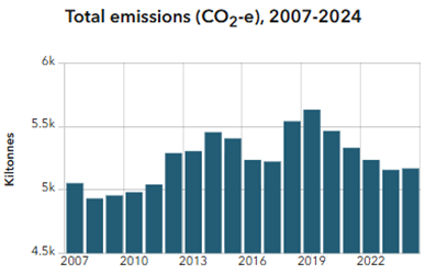
Statistics New Zealand has collected regional GHG emissions data since 2007. In Otago, total emissions peaked in 2019 at 5.6 million tonnes of CO2e. The most recent reported year is 2024, with total emissions of 5.2 million tonnes of CO2e.
Otago’s population has grown steadily since the 1990s. The main sources of regional emissions are:
- Agriculture, forestry, and fishing – 72.8%
- Transport, postal, and warehousing – 8.5%
- Households – 8.1%
Methane (63.8%) and carbon dioxide (25.3%) make up the majority of Otago’s greenhouse gas emissions.
How is it measured
Greenhouse gas emissions are measured using:
- Organisational greenhouse gas emissions inventory – Toitū Carbon Reduce programme
- Regional greenhouse gas emissions – Statistics New Zealand
Both organisational and regional emissions data are updated annually.