-
-
-
-
-
-
Research and Reports
-
-
-
-
Please use the live page for the updated layout (too hard to move all the publications)
View all the reports for the Head of the Lake Adaptation programme, as well as climate change reports and council updates.
If you have any questions about the reports and the adaptation project, please get in touch with us.
If you want to participate in the adaptation project:
A new report by Beca Ltd highlights the social and economic baseline of the community and explores how social and economic wellbeing could be impacted by natural hazard events.

An investigation by Land River Sea Consulting assessed the flood hazard of the Buckler Burn.
Tonkin + Taylor Ltd assessed possible engineering approaches to mitigate hazards or manage liquefaction and lateral spreading. Along with the Damwatch Report, it was presented to the community in June 2022.
Tonkin + Taylor presentation material - Safety and Resilience Meeting 10 May 2023
Tonkin + Taylor presentation to the Safety and Resilience Meeting 10 May 2023
A report by Damwatch Engineering Ltd focuses on how to manage three areas where floodplain hazards – flooding or erosion – may impact on the community or infrastructure in the head of Lake Wakatipu area:
-
The lower Rees River and Glenorchy township
-
The Dart floodplain and Kinloch access
-
The Rees floodplain and the Rees bridge
The report identifies potential hazard management interventions and reviews their key benefits and constraints.
Two investigations were delivered to the community in June 2022, and include a geotechnical investigation, by Tonkin + Taylor Ltd, looking at liquefaction and lateral spreading caused by a major earthquake. The second, by Land River Sea Consulting Ltd, assessed the flood hazard from the floodplain, Dart and Rees Rivers, and high levels in Lake Wakatipu.
These reports were first released to ORC and affected residents early in June. The wider public was notified afterwards.
The reports were endorsed by the Otago Regional Council on 9 June 2022.
Read the short summary (link below) of both report findings, explaining the key points with images to illustrate lateral spreading, the floodplain and what might happen in an earthquake or flood.
Liquefaction report for Glenorchy area
The geotechnical investigation, completed by Tonkin + Taylor Ltd (T+T), assessed the vulnerability of the township area to liquefaction and lateral spreading caused by a moderate to major earthquake, and the anticipated impacts of these hazards.
Independent experts peer-reviewed the report.

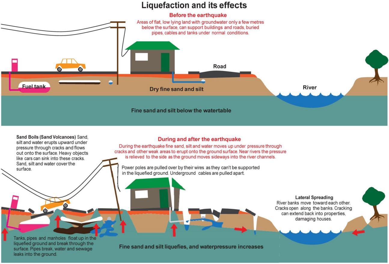
An illustration of liquefaction and lateral spreading processes and their effects (IPENZ, 2012).
Flood Hazard report
Land River Sea Consulting Ltd (LRS) assessed the flood hazard to the Dart-Rees floodplain and Glenorchy from the Dart and Rees Rivers, and high levels in Lake Wakatipu. Read the findings below.
This report was peer reviewed by independent experts, and review comments have been addressed in the finalised reports.
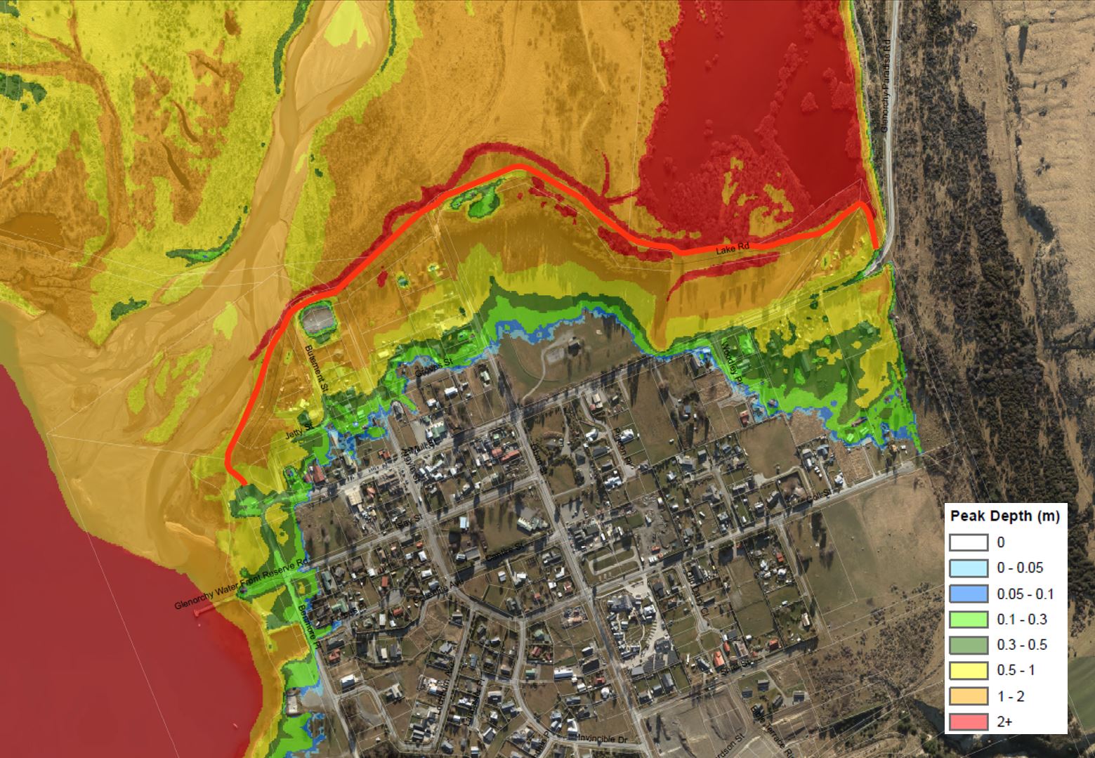
Model results for a flooding scenario at Glenorchy - these are coloured by floodwater depth.